|
Samuel de Champlain landed on this most southern tip of Nova Scotia in late May of 1604 and named the site "Cap Forchu" -- Cap meaning 'cape' and Forchu relating to 'fork', meaning well separated or cloven. The present name first appears in a grant made September 1759 in which it is provided that the tract of land hitherto known as Cape Forchu "shall be a township to be called hereafter & known by the name of the township of Yarmouth". However, the area where the lighthouse is located today continues to bear the name Cape Forchu. The Lighthouse on Cape Forchu was originally built in 1840 and replaced with a more modern structure in the early 1960s. A plaque describes the story of the lighthouse and its development. Past the parking area, a path winds its way to the Leif Ericson Picnic Park overlooking huge, sea washed rocks ( a Viking landing spot). After Champlain had secured the land to France, he left a man named de Lemeron at the cape to establish a fort, thus furthering Champlain's goals to establish the fur trade, convert the natives to Christianity and gain lands for the French Empire. This officer, de Lemeron, named the establishment after himself, Port Lemeron. Thanks to the Mi'kmaq Indians, the early expeditions
made it through the harsh winters. The friendly indians showed them how
to make shelters and how to hunt so they never froze or starved to death.
The Mi'kmaq referred to the Cape as "Kespoogwit', meaning "the end of the
earth".
Acadians In the late sixteen hundreds most settlers around
Cape Forchu were Acadian. The closest and the most noticeably Acadian community
to the Cape was Pubnico. The French community was growing quickly because
of its unique agricultural economy based on tidal dykes which drained excess
water off the marsh lands. Their sense of community was so great in 1713
that, when the Treaty of Utrecht made Acadian land British, they all agreed
to stay. They had to sign an oath to remain neutral, clearly demonstrating
that their ties to France were waning compared to the ties to their new
land. Life surrounding Cape Forchu and Yarmouth went along as usual with
fishing and agriculture till war broke out between Britain and France,
changing the face of Cape Forchu and the surrounding area to this day.
Acadian land was claimed by both sides, and so the Acadians who settled
outside of the British strongholds were once again asked to sign an oath
of allegiance to the British Crown. Wanting to remain neutral in the conflict,
the Acadians decided not to sign, believing (because of Utrecht) their
neutrality was assured. The British command feared that the Acadians who
spoke French were going to join in the French attacks so they pressured
them to sign the oath a second time. Outnumbered and threatened, and believing
the war had little to do with their thriving community, the Acadians again
refused to sign. When the oath was not signed, the British Governor Lawrence
ordered the Acadians expelled.
Lighthouses
During the 1600's and 1700's fishing, water transportation,
privateering and trade were essential to everyday life. Yarmouth Harbour
became one of the largest ports of registry of sailing ships in the world.
In the late 1800's, it was the second largest port of registry in Canada.
Shipwrec ks were common and it was recommended by Colonel Robert Morse
in 1874 that a chain of lighthouses be built along the shores of Nova Scotia
from Cape Canso to Cape Sable. Fifty-five years later it was finally decided that Yarmouth would build a lighthouse. It was started in 1839 and finished the first of January, 1840. The first day of operation was January 15, 1840. The lighthouse marked the entrance to Yarmouth Harbour and also protected ships that approached and entered the harbour. Cape Forchu's light could be seen approximately twenty miles out to sea. In 1964, the wooden building was replaced by a new concrete structure. This new light is equipped with a foghorn and its light can be seen about thirty miles out to sea.
|
|
|
|

GrassRoutes Computer Services
Ltd.
South Ohio, Yarmouth, Nova Scotia
Ph# 1-902-742-3845
Email: webmaster@grassroutes.com
All Rights Reserved
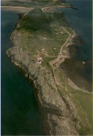
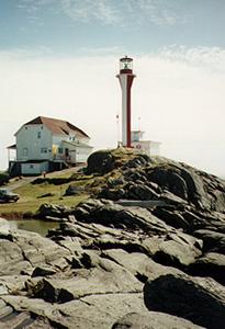
 The
rocks upon which the present day lighthouse sits have been worn smooth
by the crashing waves. Any off-trail rock climbs that take place around
the lighthouse can be quite treacherous. From the top of the rocks you
can see jagged outcrops and the water churns furiously as it enters the
inlets. One such inlet throws the waves so high in the air that it is marked
on maps as "The Churn" and it attracts photographers and artists to the
spot to capture nature's power. A gift shop is located to the immediate
right of the lighthouse and has shirts and souvenirs for the passing tourists.
Coming from the direction of town you would notice that Cape Forchu begins
with sparse woods and the forests grow thicker as you approach the lighthouse.
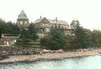
Around the Cape Forchu area is a little community called Overton where
once stood "The Markland Hotel " or " Bayview Lodge".
The
rocks upon which the present day lighthouse sits have been worn smooth
by the crashing waves. Any off-trail rock climbs that take place around
the lighthouse can be quite treacherous. From the top of the rocks you
can see jagged outcrops and the water churns furiously as it enters the
inlets. One such inlet throws the waves so high in the air that it is marked
on maps as "The Churn" and it attracts photographers and artists to the
spot to capture nature's power. A gift shop is located to the immediate
right of the lighthouse and has shirts and souvenirs for the passing tourists.
Coming from the direction of town you would notice that Cape Forchu begins
with sparse woods and the forests grow thicker as you approach the lighthouse.
Around the Cape Forchu area is a little community called Overton where
once stood "The Markland Hotel " or " Bayview Lodge".