Pinkney's PointBy:Obbie Wood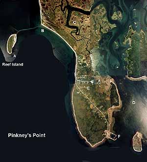
Reef Island is marked A on the map. On Pinkney's Point you can walk to Reef Island at low tide. It is a nice walk to go on but you have to be careful because, if the tide comes up over the reef, you could get stuck on the island for 12 hours until the tide goes back down. There are a few more reefs around the island and the island comes to a point so you have to watch it when you go there by boat. The letter B shows what Pinkney's Pointers call the Big Rocks. This is a breakwater and in the Groundhog Storm of 1973 all of the rocks were thrown into the road by the rough water. After the storm backhoes had to be brought in to clear the road. It is a great spot to go swimming at low tide. The sand is showing then, and there is a little bit a wave action for the young children to play in. The C on the map marks the salt marsh where farmers used to cut salt hay to feed their cattle. You can also go swimming in the channels and creeks, and there are good clamming spots down through there. However, it is not a very safe spot unless you know the marsh well, because there are sink holes and ponds that are very deep. The letter D marks what people call the Diner. During the lobster season fishermen set their pots there, but only licensed lobstermen are allowed to do so. Clams can also be found at the Diner. The letter E indicates the main village. The road goes right down to the wharf and is a nice walk for someone who enjoys a walk.The church has been on the Point for more than 100 years. The letter F is the wharf. This is where I spend most of my time fishing and swimming in the summer.When the boats come in from fishing , the wharf is very busy but in the summer it isn't all that busy. I like the wharf because it is a good fishing spot where you can catch flounder, mackerel, and pollack with your fishing rod. Just off the wharf there is an island called Ram Island because farmers used to bring their sheep and rams there for the summer. It is where a lot of seagulls go to nest and lay eggs.
|
|
|
|

GrassRoutes Computer Services
Ltd.
South Ohio, Yarmouth, Nova Scotia
Ph# 1-902-742-3845
Email: webmaster@grassroutes.com
All Rights Reserved